Section 3: Water Quality Improvements
Water Quality Improvement Goals, Schedules, and Strategies
This section summarizes the progress toward achieving the interim and final numeric goals and strategy implementation for the Highest Priority Water Quality Conditions (HPWQCs) within the applicable Hydrologic Areas (HAs) of the Carlsbad WMA during the reporting period. Identifying goals and the means to achieve them is a fundamental component of the WQIP. The goals, strategies, and schedules were established through the WQIP development process, and details are included in the current WQIP (September 2021).
The Responsible Agencies (RAs) implement strategies as part of their Jurisdictional Runoff Management Programs (JRMPs) and WQIP(s). A compilation of JRMP Annual Report data for FY23 is provided in Appendix C, demonstrating the collective efforts for jurisdictional implementation throughout the WMA. Thirteen strategies (i.e., core strategies) represent JRMP activities required by the MS4 permit, while other strategies have been identified to support progress toward WQIP goals. All strategies aim to protect, preserve, enhance, or restore water quality and designated beneficial uses of waterways within each HA. While some strategies focus on specific sources and stressors that potentially contribute to the HPWQC and PWQCs, others are more general and provide multiple water quality benefits. This multi-benefit approach is essential to maintaining and improving overall WMA health. These strategies and efforts are implemented on a regional, watershed, or jurisdictional scale, and implementation of these strategies during the reporting period is presented in Appendix D.
Over $19.8 million in RA program implementation expenditures were reported in FY23 by agencies in the Carlsbad WMA to improve water quality. This total expenditure includes funding for implementing over 70 strategies throughout the WMA, which contribute to improving or protecting water quality. The expenditures include jurisdictional program implementation, which, when combined as a watershed, resulted in the following outcomes:
- 1,952 investigations of non-storm water discharges conducted
- 1,459 non-storm water discharges eliminated
- 1,299 illicit discharges/connections eliminated
- 7,615 construction site inspections
- 4,932 existing development inspections
- 3,017 tons of debris removed from MS4 structures and facilities
- 5,494 tons of debris removed through street sweeping efforts
- 1,617 high priority development structural BMP inspections
- 104 public outreach events conducted
The RAs also participated in several regional efforts to improve water quality in the Carlsbad WMA (Appendix D). For example, RAs improved the Project Clean Water website to increase educational resources, promoted the “52 Ways to Love Your Water” pledge to spread storm water awareness, and sponsored several I Love a Clean San Diego clean-up events. Clean-up events resulted in the removal of over 21,043 pounds of trash and recyclables in the Carlsbad WMA and approximately 76,980 pounds region-wide.
Upcoming Goals and Progress
The following sub-sections present the upcoming interim and final goals and progress toward goals for each HA. Monitoring performed as part of the goal progress assessment is presented, and each sub-section concludes with strategy implementation highlights to address the respective HPWQC.
Note: Key highlights of jurisdictional implementation activities presented is not a comprehensive list of implementation outcomes.
3.1 Loma Alta Hydrologic Area
The Highest Priority Water Quality Condition (HPWQC) for the Loma Alta HA (Figure 4) is eutrophic conditions in the Loma Alta Slough between May and October. The interim and final goals, progress toward those goals, and strategy highlights are presented in the following sub-sections.
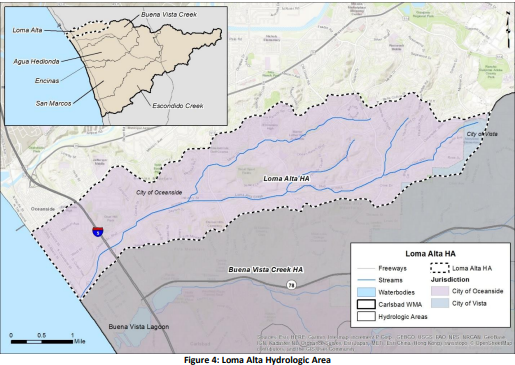
Figure of Loma Alta Hydrologic Area (Figure 4)
3.1.1 Goal Progress
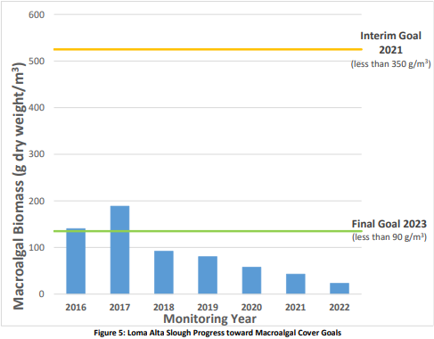
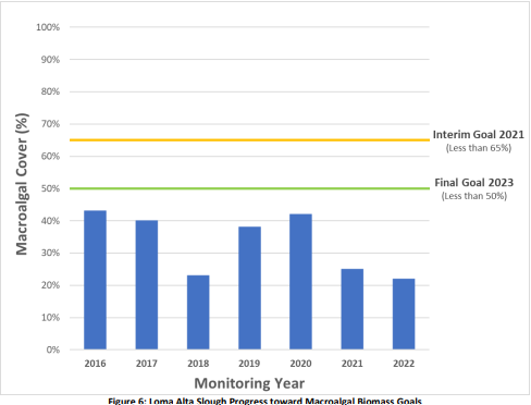
The numeric goals for Loma Alta HA are based on macroalgal biomass (grams dry weight per cubic meter – g dw/m³) and macroalgal cover (percent cover) conditions in Loma Alta Slough from May through October. The interim and final goals to address HPWQCs in the Loma Alta HA and the progress toward goals are presented in Table 4.
Results from the Long-Term Water Quality Monitoring at Loma Alta Slough Monitoring Program (Weston Solutions, 2022) confirm the successful attainment of both interim and final numeric goals, see Attachment 1 of the FY22 Carlsbad WQIP Annual Report. Furthermore, the results for 2022 show the lowest macroalgal biomass and percent cover measured in the entire history of the monitoring program. This reduction in biomass has been a consistent trend since 2017, demonstrating statistically-significant decrease.
Figure 5 and Figure 6 below compare results from the monitoring years 2016 through 2022 to interim and final goals. These figures illustrate that both macroalgal cover and macroalgal biomass goals have been consistently met since 2016 and 2019, respectively. The 2022 summer monitoring period was the final year of monitoring required under Resolution No. R9-2014-0020. This resolution required the incorporation of Loma Alta Slough’s final numeric targets into the Carlsbad WQIP and for monitoring to be conducted from 2016-2022.
During the FY23 reporting period, the City of Oceanside confirmed with the RWQCB that the monitoring program was completed after the 2022 sampling period, as both final numeric goals were met and the monitoring period specified in the Resolution has ended.
Note: The County of San Diego is no longer a Responsible Agency (RA) in the Loma Alta HA. The two parcels within the unincorporated area were annexed to the City of Vista during the reporting period.
Table 4: Loma Alta HA Progress toward Interim and Final Goals
2021 Interim Goal
| Metric | Goal Description | Results | Status |
|---|---|---|---|
| Macroalgal Biomass | Less than 350g dry wt./m³. Interim Macroalgal biomass and percent cover reduction goals are currently based on best professional judgment and historical data in Loma Alta Slough, as a reliable baseline of macroalgae data was not available at the time of RWQCB acceptance of the WQIP. The goals may be adapted as monitoring data/information is collected, analyzed, and baselines are established. Final Numeric Goals reflect those accepted by the RWQCB and described in the draft TMDL report and reiterated in RWQCB Resolution No. R9-2014-0020. | 42.87 g dw/m³ | Achieved |
| Macroalgal Cover | Less than 65% | 25% | Achieved |
2023 Final Goal
| Metric | Goal Description | Results | Status |
|---|---|---|---|
| Macroalgal Biomass | Less than 90g dry wt./m³. | 23.11g dw/m³ | Achieved |
| Macroalgal Cover | Less than 50% | 22% | Achieved |
¹ Note: Achieved goals indicate successful attainment of specified conditions within the reporting period.
Shaded italicized text denotes the selected compliance method to demonstrate progress for the interim goal. 1 Currently being achieved. Per Resolution R9-2014-0020, the City was to conduct monitoring for seven years concluding in the 2022. The final numeric goals have been met. The City of Oceanside will work with RWQCB staff in FY24 to identify a new HPWQC in the Carlsbad WMA through the adaptive management process outlined in Provision B of the MS4 Permit.
Loma Alta Slough Progress toward Macroalgal Cover Goals (Figure 5)
Loma Alta Slough Progress toward Macroalgal Biomass Goals (Figure 6)
3.1.2 Hydrologic Area Strategy Highlights
Strategies to highlight in the Loma Alta HA include the Loma Alta Slough Wetlands Enhancement Project and Garrison Creek Native Habitat Restoration Project strategies. As discussed below, both strategies are restoration efforts aimed to achieve multiple benefits including habitat enhancement, flood protection, water quality improvements, preservation of open space, and enhancing recreational opportunities. For additional strategies implemented in the HA during the reporting period, refer to Appendix D.
Loma Alta Slough Wetland Enhancement Project
The Loma Alta Slough Wetlands Enhancement Project addresses the priority eutrophic water quality condition at Loma Alta Slough and aims to achieve multiple benefits through the restoration of ecological functions and protection of infrastructure from future climate-driven impacts. The project has existed in a conceptual phase for years as the City of Oceanside worked to acquire private properties surrounding the Slough beginning in the 1990s. In 2018, the city was awarded a Proposition 1 planning grant from the
Figure 7: Loma Alta Slough
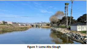
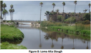
State Coastal Conservancy to complete the required studies, preliminary design, and environmental documentation for a comprehensive restoration project. The project enhances the hydrologic function and habitat quality of existing coastal salt marsh and brackish freshwater wetlands by removing invasive species, dredging new wetland areas, and removing non-native infill to widen the extent of Loma Alta Slough. The restoration improves the existing habitat by enhancing water circulation and establishing new habitat ecotones to provide refuge for sensitive coastal species. Of the total six-acre project footprint, the restoration creates an additional three acres of new wetlands at the Slough, which will play an important role in nutrient reduction by removing nitrogen and phosphorus while providing infrastructure protection from increased storm intensity and sea-level rise from expected climate change. The project design is taking a multi-benefit approach, balancing the need for water quality improvements with flood risk reduction, coastal infrastructure protection, and recreational opportunities through the inclusion of a trail system
Figure 8: Loma Alta Slough
During the FY23 reporting period, substantial progress was made in readying the project for construction. In addition to prior committed construction funding of $1M from the US Fish & Wildlife Service, the Ocean Protection Council awarded an additional over $1M in June 2022. The following was achieved in the FY23 reporting period:
-
Acquisition of three major agency permits required for construction, including a CDFW Streambed Alteration agreement, RWQCB 401 water quality certification, and Coastal Commission Development Permit;
-
Finalized the project’s 90% engineering plan set and began the City’s internal entitlement process to approve a Discretionary Development Plan for the area;
-
Coordinated project construction with three other major CIP projects surrounding the restoration footprint, which includes trail connections to a future extension of the Coastal Rail Trail through south Oceanside; and
-
City Council certification of the project’s Final CEQA Documentation, including adoption of the Mitigated Negative Declaration, Mitigation Plan and Notice of Determination
The city expects the final Construction Documents to be completed in late 2023. Pending final regulatory approvals and sufficient construction funding, the City expects to put the project out to bid in early 2024, with Phase 1 construction planned for late 2024. Implementation depends entirely on available grant funding, as concerns persist that inflationary and economic pressures have increased the estimated costs for Phase 1.
Figure 9: Graphic rendering of Phase 1 of the Loma Alta Wetlands Enhancement Project (ESA 2023).
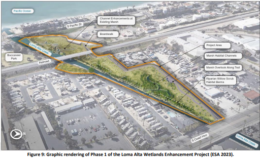
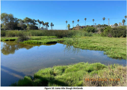
Figure 10: Loma Alta Slough Wetlands
The city is coordinating the Enhancement Project construction with three important infrastructure projects in the vicinity of Loma Alta Slough, including the future decommissioning of the La Salina wastewater treatment plant, the Coastal Rail Trail extension southward over Loma Alta Creek, and future upgrades to Buccaneer Park. Completing these projects is synergistic as they will benefit one another by encouraging climate-friendly transit, restoring historical wetland habitats, and fostering public awareness of the value of open space creation and conservation.
Figure 11: Garrison Creek Native Habitat Restoration Project
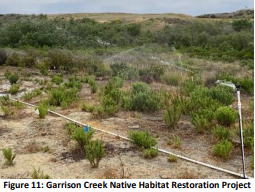
Garrison Creek Native Habitat Restoration Project In the FY23 reporting period, the City of Oceanside completed substantial work on the Garrison Creek Native Habitat Restoration Project. This project is a Supplemental Environmental Project (SEP), designed in cooperation with the RWQCB, to mitigate previous environmental impacts to the Loma Alta HA from a domestic sewage spill in 2015. The restoration work is intended to mitigate prior impacts to the Loma Alta tributary and enhance its biological and community value above its original condition. The project involves removing and controlling invasive vegetation within a 20-acre open space area of the Garrison Creek drainage and restoring over three acres of riparian forest and Diegan Coastal Sage Scrub habitat to benefit sensitive and threatened avian species. The project includes improvements to an existing public trail system with new interpretive signage to educate the community about the value of riparian habitat, restoration, and connectivity of watersheds and water quality in the Loma Alta HA. During FY23, the city worked with its restoration partners, the Nature Collective and Friends of El Corazon, to conduct multiple invasive species treatments, installation of restoration irrigation, native plants, and broadcast seeding. The project is currently in Year 5 of the monitoring period and near achieving the success criteria for native habitat establishment and invasives control. As of the last vegetation monitoring event in July/August 2023, the restoration areas have increased to over 80% native species cover, well above the SEP restoration success criteria target of 65% native cover.
Figure 12. Garrison Creek Native Habitat Restoration Project:
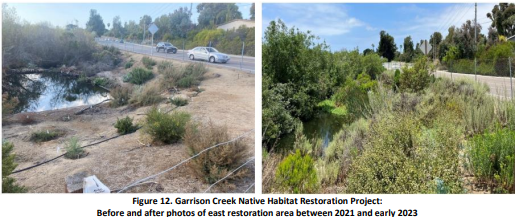
Before and after photos of east restoration area between 2021 and early 2023
3.2 Agua Hedionda Hydrologic Area
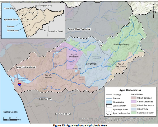
The HPWQCs for the Agua Hedionda HA (Figure 13) are riparian habitat degradation and hydromodification impacts. The interim and final goals, progress toward those goals, and strategy highlights are presented in the following sub-sections.
Figure 13: Agua Hedionda Hydrologic Area
3.2.1 Goal Progress
In the Agua Hedionda HA, restoration projects have been identified as goals to address riparian habitat degradation and hydromodification impact HPWQCs. Restoration of riparian habitats and other natural features supports healthy watersheds by providing critical habitat for wildlife, reducing creek bank erosion, maintaining stable creek channel geomorphology, and enhancing natural processes to filter pollutants such as nutrients and sediment. In the Agua Hedionda HA, goal progress is based on advancing specific project implementation, as presented in the Riparian Habitat Degradation Progress and Hydromodification Impacts Progress tables below.
Riparian Habitat Degradation Progress
| Goal Year | Goals | Baseline | Goal Achieved? |
|---|---|---|---|
| 2023 Interim Goal (2018-2023) | 50% of the Agua Hedionda Creek Restoration project schedule complete | 0% of Agua Hedionda Creek Restoration Project Completed | In Progress, Not Achieved in 2023 |
| 2028 Final Goal (2023-2028) | Completion of Agua Hedionda Creek Restoration project (8.81 acres of mitigated riparian and upland habitat) and long-term preservation through the City of Carlsbad’s Habitat Management Plan | - | In Progress |
During the reporting period, the City of Carlsbad completed permitting for geotechnical work.
Hydromodification Impacts Progress
| Goal Year | Goals | Baseline | Goal Achieved |
|---|---|---|---|
| 2023 Interim Goal (2020-2023) | 50% of wetland creation completed adjacent to 700 feet of Roman Creek | 0% of wetland creation adjacent to Roman Creek | In Progress, Not Achieved in 2023 |
| 2026 Final Goal (2023-2026) | Completion/creation of approximate 2-acre wetlands adjacent to Roman Creek in the City of Vista’s Buena Vista Park area | - | In Progress |
Solicitation of design-build services in FY 2021-22 resulted in a bid exceeding the project budget by over $2 million. The available budget for the project was carried forward in the CIP budget into FY 2022-23. The project remained on hold. The project status was discussed with the Regional Board staff. The city initiated a review of alternative hydromodification characteristics and activities. Shaded italicized text denotes the selected compliance method to demonstrate progress for the interim goal.
3.2.2 Numeric Goal Strategy Highlights
Strategies to highlight in the Agua Hedionda HA include the Roman Creek Wetland Restoration Project, Agua Hedionda Creek Restoration Project, and other efforts that address riparian habitat degradation and hydromodification impacts. For further details and additional strategies implemented in the HA during the reporting period, refer to Appendix D.
Agua Hedionda Creek Restoration Project
The City of Carlsbad’s Agua Hedionda Creek Restoration Project focuses on restoring riparian habitat areas to improve flood control, reduce erosion, stabilize riverbanks, increase habitat connectivity and quality, and improve water quality.
In FY17, Carlsbad met its goal by restoring 3.6 acres of wetland habitat near Agua Hedionda Creek and removing invasive species. In FY22, the city completed its fifth year of vegetation maintenance.
FIGURE 14
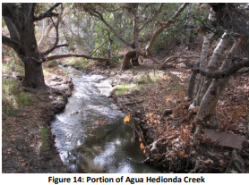
The city is in progress toward achieving the next interim goal (2023) and final goal (2028), as identified in Table 5. In FY22, the City of Carlsbad awarded a $1,919,294 contract to support the extension of College Boulevard to the east of El Camino Real at Sunny Creek Road. The extension of College Boulevard is a long-term project, and creek restoration is planned to be completed as part of the project. Tasks to be completed through the issued contract include, but are not limited to:
- Surveying
- Preliminary environmental impact and mitigation assessment
- Preliminary hydraulic and hydrological studies
- Preliminary geotechnical engineering investigation
- Preliminary civil engineering plans
- Preliminary storm water quality management plan
- Preliminary construction cost estimates
- Community outreach program
In FY22, the city completed the traffic mobility analysis, preliminary environmental field work, and the preliminary hydraulics study. In FY23, the city continued execution of the consultant contract by completing the permits for the geotechnical work necessary for the engineering design. The city’s Planning Department received preliminary cost estimates for discussions with relevant developers.
While progress toward creek restoration has occurred, the city recognizes that achieving the 2023 interim and 2028 final restoration goals is in jeopardy. Under the city’s Growth Management Program, money from residential developer fees helps fund the infrastructure needed to support the corresponding increase in population. In the case of the College Boulevard extension, most of the adjacent properties don’t have active development plans, and not all landowners in the area are planning to develop soon, leading to a lack of funding and a delay of the overall project.
Although the Agua Hedionda Creek Restoration Project is delayed, and the final construction timeline is unknown, the city has been actively implementing programmatic strategies within the Agua Hedionda HA that have similar water quality benefits as creek restoration. Attachment 2 of the FY22 CWMA WQIP Annual Report summarizes the city’s overall efforts.
In recognition of not achieving the 2023 Interim Goal, during FY24, the city will initiate an adaptive management process to reconsider the HPWQC and existing numeric goals. This process will involve close collaboration with the RWQCB, a reevaluation of priority water quality conditions, hydrologic area
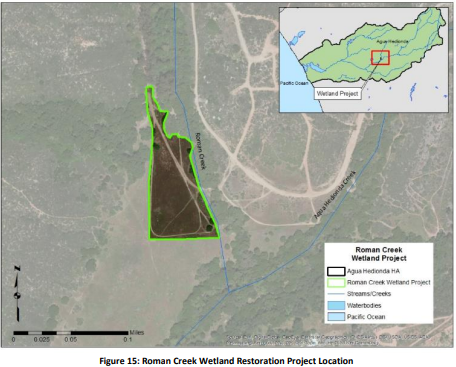
Roman Creek Wetland Restoration Project
Roman Creek is tributary to Agua Hedionda Creek and flows through Buena Vista Park (Figure 13). The Roman Creek Wetland Restoration Project is identified in the Carlsbad WMA WQIP as a strategy for wetland creation and enhancement to address hydromodification impacts and as a mitigation strategy to compensate for aquatic resource impacts from other city projects. Previous Carlsbad WMA annual reports detail field studies, design efforts, and environmental permitting activities associated with the Roman Creek project. To date, the city has expended $1,136,000 on the project.
FIGURE 15
As previously reported, a request for proposals (RFP) was released in September 2021, soliciting design-build services for the Roman Creek project. The RFP detailed the full scope of services to design and construct the project to accomplish the WQIP numeric goal. In October 2022, one bid of $6,000,000 was submitted, which, while deemed acceptable, surpassed the allocated budget by over $2,300,000. Consequently, the city paused the project to consider value engineering options and evaluate funding during its Spring 2022 Capital Improvement Budget process. Based on the capital project needs for overall sewer system capacity and replacement projects, sufficient funds were unavailable to bridge the Roman Creek project funding gap. The city recognizes that achieving the 2023 interim and 2026 final wetland creation goals is in the balance.
During FY23, the city explored alternative actions that could provide similar benefits to the Roman Creek project. Unfortunately, within the area tributary to Roman Creek, opportunities for retrofit projects or new developments with comparable benefits are limited. The area is relatively small, fully developed, and home to significant homeowner associations where redevelopment is unlikely in the foreseeable future. However, the city has identified a potential opportunity to expand the detention/retention capacity of a small basin upstream of the Roman Creek project site. While the benefits of this action are not yet quantified, the city is actively investigating its feasibility as a replacement for the Roman Creek project or, at the very least, as a complementary measure alongside adaptive management efforts related to High Priority Water Quality Control (HPWQC) and numeric goal adjustments.
In recognition of not achieving the 2023 Interim Goal, in FY23, the city initiated adaptive management efforts to reconsider the existing interim and final numeric goals. In FY24, this process will involve close collaboration with the RWQCB, a reevaluation of priority water quality conditions and hydrologic area characteristics, and the potential development of revised numeric interim and final goals. Subsequent annual reports will provide updates on the city's progress.
Program for Stream, Channel, and/or Existing Habitat Rehabilitation in Areas of Existing Development
Each RA developed rehabilitation programs as part of their jurisdictional programs to identify areas of streams, channels, and/or habitats that are candidates for rehabilitation and look for opportunities to implement projects. While all RAs implemented this program during FY23, the City of Carlsbad implemented a vegetation maintenance project in the Agua Hedionda HA to mitigate flooding impacts and protect riparian habitat.
Agua Hedionda Creek Vegetation Maintenance Project
Within the City of Carlsbad, long-term maintenance of Agua Hedionda Creek between the Cannon Road and El Camino Real bridges is necessary to reduce flooding upstream. To improve the creek's flood capacity, limited vegetation is permitted within this portion of the creek. This project is a five-year project per the CDFW Streambed Alteration Agreement (SAA) Notification No. 1600-2013-0302-R5. The permit was extended through 2024, and associated work was performed in October 2022 and February 2023. Creek vegetation maintenance is vital to support optimal creek conveyance capacities and flood protection benefits. Vegetation maintenance removes obstructions from the channel, maximizing the flow potential and reducing the risk of flooding upstream.
3.3 San Marcos Hydrologic Area
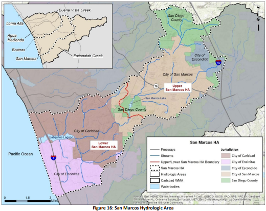
The San Marcos HA has two distinct areas separated by the Lake San Marcos impoundment – the Upper San Marcos and Lower San Marcos HAs (Figure 16). The Lower and Upper San Marcos HAs have different HPWQCs. The HPWQCs, interim and final goals, progress toward those goals, and strategy highlights for the Upper San Marcos HA and Lower San Marcos HA are presented in Section 3.3.1 and 3.3.2,respectively.
FIGURE 16 San Marcos Hydrologic Area
3.3.1 Lower San Marcos Hydrologic Area
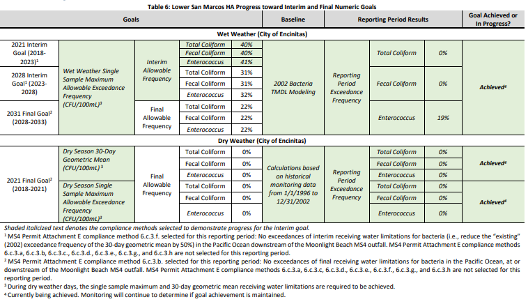
The HPWQC for Lower San Marcos HA isthe impairment ofrecreational (REC-1) beneficial use due to Fecal Indicator Bacteria (FIB) (i.e., total coliform, fecal coliform, and Enterococcus). Although Moonlight Beach has never been listed on the 303(d) list for REC-1 impairment, the beach continues to be monitored for compliance with the Twenty Beaches and Creeks TMDL. The interim and final goals (based on final receiving water limitations identified in the TMDL), progress toward goals, and strategy highlights are presented in the following sub-sections.
Table 6: Lower San Marcos HA Progress toward Interim and Final Numeric Goals
3.3.1.2 Highest Priority Water Quality Condition Strategy Highlights
Strategies highlighted in this section include the ultraviolet (UV) bacteria treatment facility strategy, evaluation of the sanitary sewer maintenance and overflow protection strategy, and the pet waste bag dispensers strategy. These strategies target FIB reductions through treatment and source control and support progress toward interim and final goals. For additional strategies implemented in the Lower San Marcos Creek portion of the HA during the reporting period, refer to Appendix D.
Evaluate Sanitary Sewer Maintenance and Overflow Prevention
Evaluation of sanitary sewer maintenance and overflow protection targets anthropogenic sources of FIB and contribute to decreased FIB levels in the Lower San Marcos HA. The City of Encinitas has an annual sewer line maintenance schedule. The city utilizes a “hot-spot” cleaning list for observed or documented sewerline anomalies such as low flows, dips, or historic root problems. Encinitas maintains a 5-year closed-circuit television (CCTV) inspection cycle for all sewer lines throughout the city. Sewer spill records and a holistic assessment of the city’s sewer system maintenance program have concluded that there is no need for a change in maintenance frequency or FOG program policies at this time.
Ultraviolet Bacteria Treatment Facility
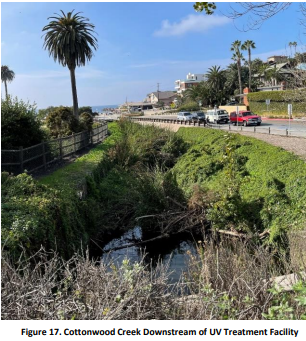
The City of Encinitas operates a UV treatment facility just upstream of Moonlight Beach, eliminating 99% of the FIB passing through the system. The city has an administrative agreement with the San Elijo Joint Powers Authority (SEJPA) to perform preventative and regular UV treatment facility maintenance, including daily monitoring, inspections, and startup and shutdown of the facility as dictated by rain events. In FY23, the facility was non-operational through continuous rain events beginning late December 2022 through mid-April 2023, as well as for short periods during other rain events throughout the reporting year. Despite observed winter rainfalls that nearly doubled historical annual averages, the facility was in operation for 214 days during the monitoring period. The daily average volume of water that passes through the UV treatment facility is approximately 144,000 gallons per day, which resulted in the treatment of an estimated 30.8 million gallons of flow during the reporting period. Riparian habitat along Cottonwood Creek downstream of the UV treatment facility is illustrated in Figure 17 above.
Pet Waste Bag Dispensers
If left on the ground, pet waste can be a source of bacteria in receiving waters. During the reporting period, the City of Encinitas, the City of Carlsbad, and the County of San Diego continued to encourage and promote proper pick-up and disposal of pet waste by providing pet waste bag dispensers in public areas, including city parks and trails.
3.3.2 Upper San Marcos Hydrologic Area
The HPWQC for the Upper San Marcos HA is nutrients. The interim and final goals, progress toward the goals, and strategy highlights are presented in the following sub-sections.
3.3.2.1 Goal Progress
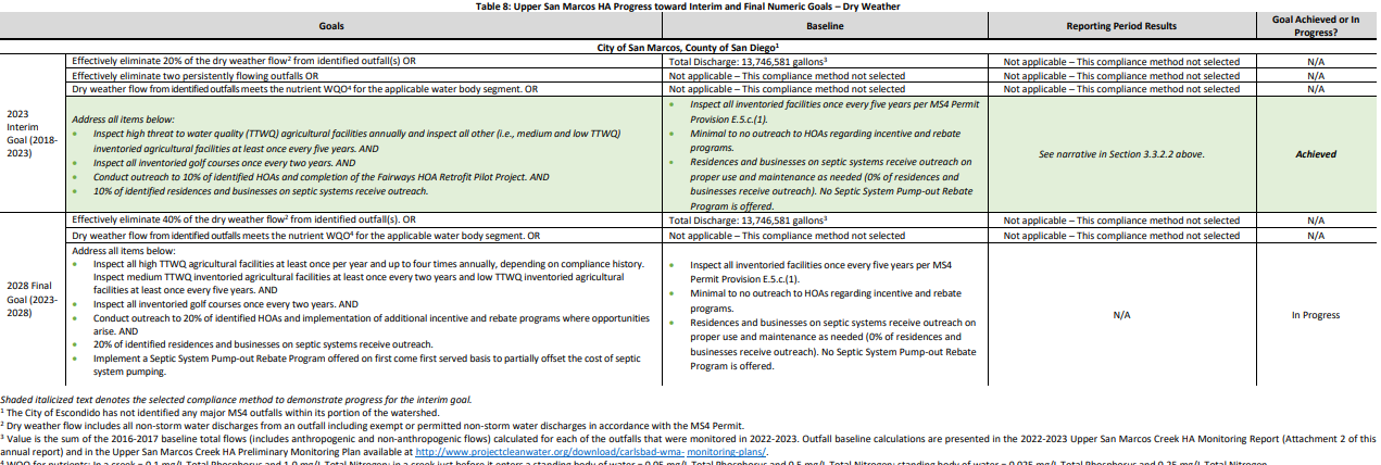
The interim and final goals for the Upper San Marcos HA are presented below in the narrative and summarized in Table 7 on the following pages. The detailed monitoring and assessment results are presented in the Upper San Marcos Creek HA 2022-2023 Monitoring Report (Attachment 2) and MS4 Outfall Monitoring Report (Attachment 3).
3.3.2.2 Numeric Goal Strategy Highlights
The following are numeric goal strategy highlights in the Upper San Marcos HA:
Enhanced Agricultural Facility Inspections
During FY23, there was a total of 84 inventoried commercial agricultural facilities within the Upper San Marcos HA. Of the 84 inventoried facilities, 83 have received at least one inspection since July 2021. The Responsible Agencies conducted 147 on-site inspections at these facilities (76 were conducted at sites ranked as high TTWQ and 71 were conducted at medium TTWQ sites). There were no sites ranked as low TTWQ. Sites not inspected during FY23 are scheduled to be inspected in FY24.
Enhanced Golf Course Inspections
The Responsible Agencies inspected all three inventoried golf courses in FY23. One site had violations related to routine maintenance. All violations were resolved, and corrective actions were completed within 30 days.
HOA Outreach
In FY23, eight of twenty-two (36%) identified HOAs were provided outreach on the County's Waterscape Rebate Program. Outreach included phone calls, emails, and/or in-person meetings. Six HOAs are participating in the Program's Landscape Optimization Service where each HOA has committed to converting at least 10,000 sf of turf grass to sustainable landscaping.
Fairways HOA Retrofit Pilot Project
In FY19-20, the County initiated a partnership with The Fairways HOA in the Lake San Marcos area (MS4-CAR-072 Drainage/Focus Area) with the goal of establishing a pilot demonstration project for the County’s Waterscape Rebate Program. The pilot project included replacing old irrigation controllers with smart weather-based irrigation controllers. The HOA installed four new controllers that operate 136 stations and completed nozzle upgrades. Five years (June 2018 through June 2023) of water usage data collected from four dedicated irrigation meters at The Fairways HOA indicate an approximately 36% decrease in water usage since completing the project. It should be noted that there was a 53.07% dry weather flow reduction measured at Outfall MS4-CAR-072 during the 2022-2023 monitoring year. After completion of the pilot project, the HOA also replaced approximately 23,000 square feet of turf with sustainable landscaping, including 10,000 square feet with native plants, as shown in the images below.
Septic System Outreach
Based on available data, the Responsible Agencies have identified 53 residences and businesses that are likely on septic systems. A total of 26 of the 53 (49%) identified residences and businesses received outreach consisting of mailed letters and fliers.
For additional strategies implemented in the HA during the reporting period, refer to Appendix D.
Figure 18: Fairways HOA Turf Replacement Project - Before
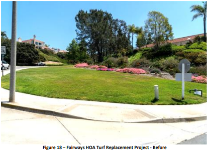
Figure 19: Fairways HOA Turf Replacement Project - After
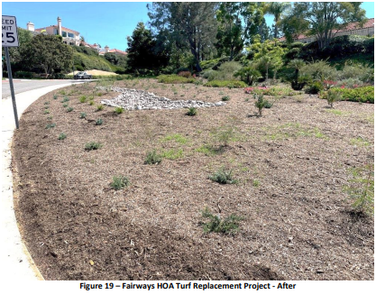
Table 7: Upper San Marcos HA Progress toward Interim and Final Numeric Goals – Wet Weather

Shaded italicized text denotes the selected compliance method to demonstrate progress for the interim goal.
1 The baseline value represents the 2010-2011 wet weather load. 2 Currently being achieved. Monitoring will continue to determine if goal achievement is maintained. 3 WQO for nutrients: In a creek just before entering a standing body of water = 0.05 mg/L Total Phosphorus and 0.5 mg/L Total Nitrogen. In the future, site-specific WQO may be developed.
Table 8
3.3.2.3 Highest Priority Water Quality Condition Strategy Highlights
Implement Preferred Watershed Remedy as Proposed through the Final Corrective Action Plan
The City of San Marcos, the County of San Diego, and the City of Escondido continue to move forward with the preferred watershed remedies recommended in the Final Remedial Investigation/Feasibility Study (RI/FS) for the Upper San Marcos Creek HA. Table 9 summarizes the completed activities during this reporting period. A description of the various completed activities is detailed in Appendix D. All data and documentation related to the Lake San Marcos and Upper San Marcos Creek Water Quality Investigation can be viewed and obtained at the State of California GeoTracker website4.
Figure 20
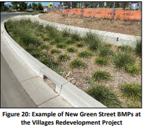
Table 9: FY23 RI/FS Efforts Conducted
| Date | Item and Comments |
|---|---|
| December 30, 2022 | Lake San Marcos 2022 Aeration Pilot Study Report – submitted to San Diego RWQCB. |
| March 14, 2023 | Lake San Marcos Bridge Document Draft 2 March 2023 – submitted to San Diego RWQCB. |
Escondido Country Club Redevelopment and Runoff Treatment Project
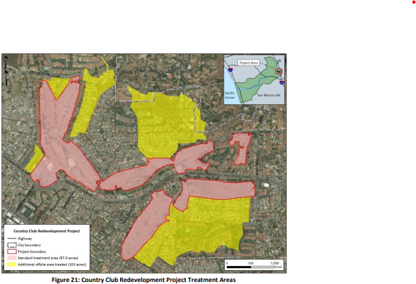
The Escondido Country Club golf course in the City of Escondido was closed and rezoned for residential development. The former golf course property is being redeveloped into a residential master-planned community known as Canopy Grove. The Canopy Grove project site encompasses 97.5 acres and will have structural biofiltration BMPs to treat runoff (Figure 21).
The City of Escondido’s development agreement negotiated in FY18 requires the developer to treat over 100 acres of existing neighborhoods outside the project site. In total, runoff from 106 off-site acres will be routed to the structural biofiltration BMPs within the development. One area too large to commingle into a biofiltration basin is being treated through a baffle box that will collect trash, debris, and sediment from existing upstream neighborhoods.
The developer has also agreed to incorporate a nutrient-sensitive design for the biofiltration BMPs, including a reduced-compost media composition (10% compost) to guard against nutrient export. In addition to the land use change, this treatment is estimated to reduce nutrient loading in the Upper San Marcos HA by 37 kg/year, especially when compared to the historically active golf course. This calculation assumes the same loading estimates for golf courses and residential areas, described in the RI/FS, applied to the same proposed land use acreage to be treated by this project for those land uses.
Construction of the Canopy Grove project continued in FY23. Grading is complete, and nearly all 380 homes and the commercial village center are complete. In Villages 1 and 3, the nutrient-sensitive stormwater treatment basins were completed, and the remaining basins have been excavated and are waiting for the media to be placed. Offsite work continued, including a new signal light being installed at Nutmeg Street and County Club Lane.
Figure 21
Implement Structural or Retrofit BMPs
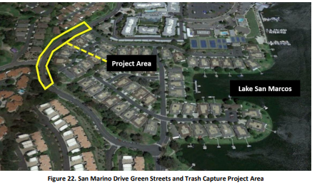
San Marino Water Quality Improvement Project
San Marino Drive is located upstream of one of the County’s highest priority persistently flowing outfalls, MS4-CAR-072, in the community of Lake San Marcos. The project will treat runoff from approximately 27 acres with a full trash capture device and will treat the runoff from approximately 4.5 acres of adjacent surface streets with biofiltration basins.
The goal of the project is the reduction of nutrients, sediment, debris, bacteria, and trash found in the County storm drain system. Construction of the project will begin in FY24 and is expected to be completed in FY24.
Figure 22
3.4 Escondido Creek Hydrologic Area
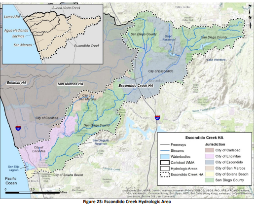
Riparian habitat degradation is the HPWQC for the Escondido Creek HA (Figure 23). The interim and final goals, progress toward those goals, and strategy highlights are presented in the following sub-sections.
Figure 23: Escondido Creek Hydrologic Area
3.4.1 Goal Progress
In the Escondido Creek HA, the Spruce Street Channel Rehabilitation Project (Spruce Street Project) is identified as a goal to address riparian habitat degradation. Monitoring of goal progress is based on the advancement of project implementation, as presented in Table 10.
2023 Interim Goals (2018-2023)
| Goals | Baseline | Goal Achieved or In Progress? |
|---|---|---|
| Prioritize the implementation of trash policy measures, as needed per State requirements, in drainage area ESC_134 (737 acres) to benefit Spruce Street Project OR 0 trash capture devices installed | 0 trash capture devices installed | Achieved |
| Complete 130 feet of the construction for Spruce Street Project (Phase 1 - Valley Parkway overpass, 9% of total project length) OR | 0 feet of construction for Spruce Street Project | Achieved |
| Removal of invasive species and accumulated sediment from a 250 foot long portion of the Spruce Street Project area | 0 feet of project area improved | Achieved |
2028 Interim Goals (2023-2028)
| Goals | Baseline | Goal Achieved or In Progress? |
|---|---|---|
| 50% of Spruce Street Rehabilitation Project complete | 0% | Achieved |
2030 Final Goals (2028-2030)
| Goals | Baseline | Goal Achieved or In Progress? |
|---|---|---|
| Prioritize the implementation of trash policy measures, as needed per State requirements, in drainage area ESC_134 (737 acres) to benefit Spruce Street Project OR 0 trash capture devices installed | 0 trash capture devices installed | Achieved |
Shaded italicized text denotes the selected compliance method to demonstrate progress for the interim goals
Wet and Dry Weather (City of Escondido)
As reported in the FY18 and FY19 Annual Reports, the City of Escondido installed trash capture devices at approximately 32 storm drain inlets upstream of the Spruce Street Project. The devices have been functioning properly and maintained by the Public Works Department. This effort achieved the 2023 interim numeric goal of prioritizing the implementation of trash policy measures.
Construction for all sections of the Spruce Street Project was initiated in July 2019. Removal of invasive species and accumulated sediment occurred in FY20. Major grading and construction work was completed in FY21. Plant installation was substantially completed in FY22. Plant establishment, vegetation maintenance, and erosion control measures continued through FY23. Final agency sign-off for project revegetation is expected in FY24, at which time the project will be deemed completed.
3.4.2 Numeric Goal Strategy Highlights
Strategy highlights in this section present the efforts to establish and improve riparian habitat/native vegetation in the Escondido Creek HA. Riparian/native vegetation are essential components of healthy watersheds that provide critical habitat for wildlife, work as buffers to filter pollutants such as nutrients and sediment, reduce creek bank erosion, and maintain stable creek channel geomorphology. For additional strategies implemented in the HA during the reporting period, refer to Appendix D.
City of Escondido: Spruce Street Channel Rehabilitation Project (Spruce Street Project)
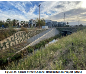
The City of Escondido has made steady progress toward Escondido Creek HA interim and final goals. During FY22, construction work and plant installation were completed (Figure 24). Plant establishment, vegetation maintenance, and erosion control measures continued through FY23. Final agency sign-off for project revegetation is expected in FY24, at which time the project will be deemed completed.
Figure 24: Spruce Street Channel Rehabilitation Project (2021)
3.4.2.1 High Priority Water Quality Condition Strategy Highlights
Reidy Creek Enhancement
The City of Escondido continued efforts to improve riparian habitat in the lowest earthen section of Reidy Creek just north of SR-78 before it becomes channelized and joins with Escondido Creek. The city supported the Escondido Creek Conservancy in implementing a $380,873 California Department of Fish and Wildlife Proposition 1 grant to remove over 600 non-native trees, including Mexican Fan Palms. The grant was awarded in early 2019 and the grant activities were completed in February 2022. The project included developing a long-term management plan as part of the city’s Landscape Maintenance District program and the installation of trash capture devices upstream of the project area.
In April 2023, City staff partnered with the Escondido Police Department and I Love a Clean San Diego to host Coastal Cleanup Day. Nearly 40 volunteers came together to clean up Reidy Creek.
San Elijo Lagoon Restoration
The San Elijo Lagoon is a valuable resource within the Escondido Creek HA, and efforts for the lagoon restoration project are underway. The $120 million restoration project broke ground in November 2017 and is part of the Build North Coast Corridor program of the San Diego Association of Governments and Caltrans. The San Elijo Lagoon Restoration Project (SELRP) includes:
- Vegetation clearing and building a series of dikes along the main lagoon channel and inlet to control water elevations and turbidity
- Dredging various channels within the lagoon to increase tidal flow
- Restoring mudflats
- Establishment of new wetland habitat
- Creation of new pedestrian trails
In August 2022, the Nature Collective released the 2021 Wetland Habitat and Hydrology Annual Monitoring Report for the San Elijo Lagoon Restoration Project (AECOM, 2022). The Report summarized the status of the SELRP post-construction for 2020 and 2021, Year 0 and Year 1, respectively. For Year 1, the performance standards for topography, bathymetry, tidal elevations, habitat areas, vegetation cover, exotics cover, wetland function, eelgrass, and Caulerpa were met. The report also noted that performance standards for water quality, benthic invertebrates, and fish could not be fully evaluated as additional years of data are needed to calculate the 4-year running averages. To date, no further monitoring reports have been published. As managing partners of San Elijo Lagoon Ecological Reserve, the County of San Diego Department of Parks and Recreation, Nature Collective, and CDFW will continue to protect sensitive natural resources.
3.5 Buena Vista Creek and Encinas Hydrologic Areas
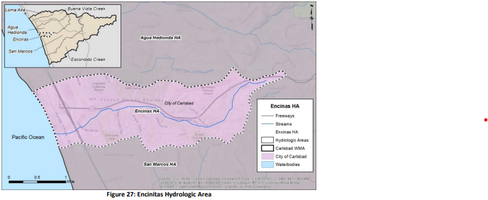
Currently, no HPWQCs are identified in the Buena Vista Creek and Encinas HAs (Figure 26 and Figure 27, respectively). Without HPWQCs, no interim and final goals for the HAs are established. However, the Buena Vista Creek and Encinas HA RAs implemented strategies in the HAs to protect or improve water quality. Appendix D lists and summarizes efforts in the Encinas and Buena Vista Creek HAs.
Figure 26 Buena Vista Hydrologic Area
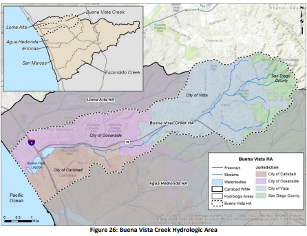
Figure 27 Encinas Hydrologic Area
